| Accompanying Lewis map for Wexford 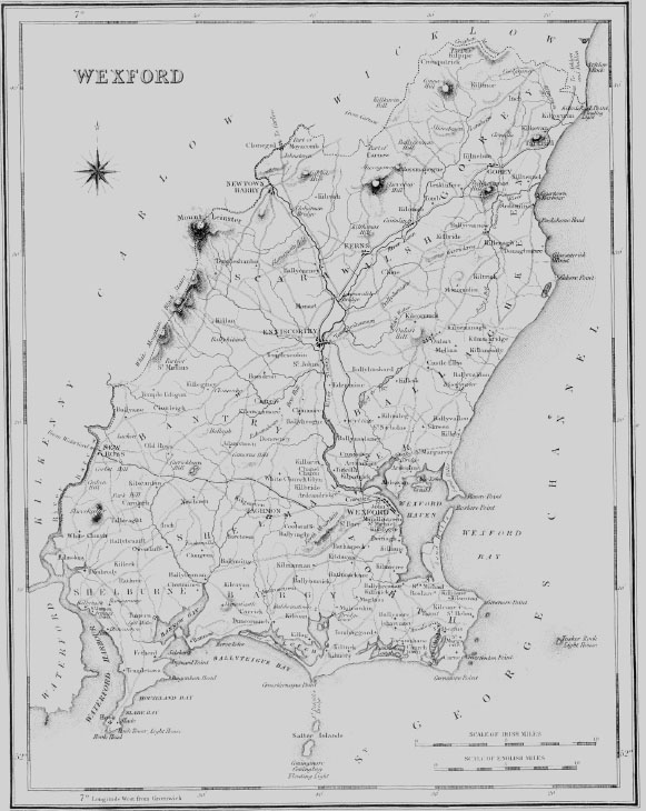
|
| KILMORE |
| KILMORE, a parish, in the barony of BARGY, county of WEXFORD, and province of LEINSTER, 9- miles (S. S. W.) from Wexford ; containing 1796 inhabitants. This place is situated on the eastern shore of the lough formed by the burrow of Ballyteigue, a long narrow sand bank extending from Ballyteigue for nearly four Irish miles, to the entrance of the lake at its western extremity : the burrow abounds with rabbits, and the lake with a variety of wild fowl. The parish comprises 3331 statute acres, which are partly good grazing land, but principally under tillage ; the soil is fertile, and the system of agriculture has been much improved ; with the exception of the burrow, there is neither bog nor waste land. Limestone exists on the lands of Ballycross, but has not yet been quarried ; an abundance of sea manure, or tag weed, procured at spring tides and after storms, affording an excellent dressing for the lands. Good building stone is found on the townland of Sarcilla. The seats are Ballycross, that of J. Rowe, Esq. ; Ballyharty, of S. Green, Esq. ; Ballyseskin, of H. Archer, Esq. ; and Ballyteigue, of J. Young, Esq. At Crossfarnogue Point is a small pier, where coal is occasionally landed ; and more than 100 boats, averaging four men each, all of which rendezvous here, are engaged in the herring, lobster, and cod fisheries off this coast. The construction of a good pier at this point, which might be accomplished at an expense of about £1500, would afford protection to the numerous fishing vessels frequenting the place, and enable the fishermen to render more effectual assistance to vessels in distress. The steamboat Water Witch was wrecked off this place in 1833, and several lives were lost. The present pier is small and of very rude construction, having been built by the fishermen themselves, about 25 years since. The tide at this point rises from 11 to 12 feet at high water of springs, and 6 feet at neap tides. A coast-guard station, one of the six forming the district of Wexford, has been established at the point. The parish is in the diocese of Ferns ; the rectory is impropriate in John Rowe, Esq., of Ballycross, and the vicarage forms part of the union of Tomhaggard. The tithes amount to £453. 2. 8-., of which £337. 7. 8-. is payable to the impropriator, and £115. 15. to the vicar. In the R. C. divisions it is the head of a union or district, comprising also the parishes of Mulrankin, Tom haggard, and Kilturk, in each of which, except the last, there is a chapel ; that of Kilmore is a spacious building, erected in 1803, adjoining which a house for the priest has been lately built. There are two schools under the New Board of Education, chiefly supported by the proceeds of an annual charity sermon and a public dinner : a parochial school-house also has been recently erected. Near Crossfarnogue Point, where was formerly a telegraph, are the remains of Ballyteigue castle, formerly belonging to the Whitty family, and now incorporated with the modern mansion of J. Young, Esq. |
| SALTEE ISLANDS |
| SALTEE ISLANDS, in the barony of BARGY, county of WEXFORD, and province of LEINSTER. These islands, consisting of the Great and Little Saltee, are situated in St. George's Channel, off the coast of the parish of Kilmore, in lat. 52? 8' 30" (N.), and lon. 6? 41' (W.) ; they are extra-parochial. The Great Saltee is four miles from the shore at the village of Crossfarnogue, and three leagues (W.? S.) from the Blackrock ; it is of an elliptical form, about one mile in length and half a mile broad, and comprises about 130 acres, of which about one-third is under tillage and the remainder in pasture ; and from the abundance of sea-weed found on its shores, it is rendered peculiarly fertile. It is the property of H. K. G. Morgan, Esq., of Johnstown Castle, from whom it is rented by a farmer, whose family and labourers, about 20 persons, constitute its population. The island is amply supplied with water from several springs, and is frequented by a great variety of wild fowl that breed here during the summer months ; it is consequently much visited by shooting parties. A detachment of two men from the coast-guard station at Crossfarnogue is sta tioned here. The vestiges of numerous houses indicate that the island was formerly thickly inhabited ; on the eastern extremity, still called the Abbey point, are the ruins of a building supposed to have been a religious house. Stafford, the governor of Wexford, who is said to have betrayed that town to Cromwell, retreated hither and built a cottage which still bears his name. Bagnal Harvey, Commander-in-Chief, and Colclough, a general of the insurgent forces during the disturbances of 1798, who had taken refuge here after their defeat, were discovered in a cave and made prisoners. The Little Saltee island is about 2? miles from the shore, with which it is connected by a narrow ridge of shingle, called St. Patrick's bridge, about two-thirds of which are dry at low water ; it contains about 80 acres and is inhabited by a family consisting of three persons. The channel between the two islands is from four to five fathoms deep. Off the north-west point of the Great Saltee a vessel may anchor in five or six fathoms. The Coningmore rock, always above water, lies a mile and a half (S. by W.) from its south-west point ; and about a mile (S. W. by W.) from it is the Coningbeg rock, which appears at half ebb. Outside of these rocks is placed a light-ship having two lanterns, at an elevation of 25 feet above the sea at high water mark, displaying a bright light visible at the distance of nine nautical miles in clear weather. On part of the narrow ridge between the Little Saltee and the mainland, called St. Patrick's Bridge, are from seven to ten feet at low water ; and on the west side of it is the small fishing harbour of Crossfarnogue. From these islands to Hook Tower, a distance of five leagues, the intermediate space is a large bay with a continual in-draught and heavy sea setting in towards the shore, and dangerous from rocks and shallows, known only to persons well acquainted with this coast. Numerous vessels have been wrecked here: should a vessel get too far into this bay, it is impossible to beat out, and there is no place of refuge except Fethard, which, though it has a small pier, can afford no shelter, from the shallowness of its water and its exposed situation. |
|