| Accompanying Lewis map for Sligo 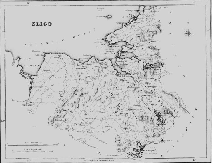
|
| AHAMPLISH |
| AHAMPLISH, a parish, in the barony of LOWER CARBERY, county of SLIGO, and province Of CONNAUGHT, 9 miles (N. N. W.) from Sligo; containing, with the villages of Ballintample and Grange, and the islands of Innismurray and Dernish (which are separately described), 7483 inhabitants. It is situated on the north-west coast, near the entrance to the bay of Sligo, and on the road from Sligo to Ballyshannon; and comprises 9286 statute acres, of which 6509 are applotted under the tithe act, and of which, also, 7311 are arable and pasture, and 1975 bog and waste. The surface is naked and unadorned, having only one small wood on the lands of Grellagh, near the river Bunduff, the estate of Viscount Palmerston, who is proprietor of the greater part of the parish. The mountain of Benbulbin extends in a direction from east to west, and separates this parish from Drumcliffe. The principal village is Grange, consisting of one street, in which are only four decent houses, and the rest are thatched cabins. Some improvement in the mode of tillage has taken place of late years, but the system of husbandry is comparatively still very deficient, and the farming implements are of a very inferior kind: limestone and turf are plentiful. A great extent of bog has been reclaimed by Lord Palmerston, who has also planted large scopes of sandy banks with bent. Considerable improvements at Mullaghmore have been made exclusively by the direction and at the expense of that nobleman, which are noticed under the head of that place. There is a salmon fishery in the river Bunduff; and at Mullaghmore several boats were formerly employed in taking turbot, cod, and other kinds of fish, which abound on this part of the coast. There are some corn-mills in the parish. The principal seats are Moneygold, the residence of J. Soden, Esq.; Streeda, of Booth Jones, Esq.; Grange, of the Rev. C. West, the incumbent; and Creenymore, of the Rev. J. McHugh, P.P. Seven fairs for live stock are held at Grange; and a fair on Feb. 1st is held at Cliffony, which has also a penny post from Sligo. Grange is both a coast-guard and a constabulary police station. The living is a vicarage, in the diocese of Elphin, and in the patronage of the Bishop; the rectory is impropriate in Lord Palmerston. The tithes amount to £221. 10. 9., divided in moieties between the impropriator and the incumbent. The church is a plain edifice, built in 1813, for which the late Board of First Fruits granted a loan of £700, and Lord Palmerston contributed £100: it contains a marble monument to the Soden family, with an inscription recording the death of James Soden, in 1705, at the age of 109 years : the Ecclesiastical Commissioners have lately granted £119 for its repair. There is neither glebe nor glebe-house. The R. C. parish is co-extensive with that of the Established Church: there are two chapels, situated at Grange and Cliffony, and built at the sole expense of Lord Palmerston. Three schools are supported principally by his lordship, each of which has a house and garden, and in which are 170 boys and more than 100 girls; and in other private schools are taught more than 100 boys and 60 girls. |
| BALLINTAMPLE |
| BALLINTAMPLE, a village, in the parish of AHAMPLISH, barony of LOWER CARBERY, county of SLIGO, and province of CONNAUGHT, 13 miles (N.) from Sligo; containing 20 houses and 110 inhabitants. It is situated on the peninsula of Mullaghmore, and is a station of the coast-guard. |
| DERNISH |
| DERNISH, or DERRINISH, an island, in the parish of AHAMPLISH, barony of LOWER CARBERY, county of SLIGO, and province of CONNAUGHT, 10 miles (N. N. E.) from Sligo : the population is returned with the parish. This island is situated near the entrance of Milkhaven, on the north-west coast, and contains about 76 statute acres of land, the property of Lord Palmerston. On its south-west side is safe anchorage in all weather in two fathoms. About ? a mile north of it is Carrignaspanach rock, which lies off the entrance of the haven, and the Tyrconnell rock is about ? of a mile from the shore Milkhaven is situated about three leagues east of the point of Ballyconnell ; the entrance is difficult, and only adapted for vessels drawing from 6 to 8 feet of water. |
| GRANGE |
| GRANGE, a village, in the parish of AHAMPLISH, barony of LOWER CARBERY, County of SLIGO, and province of CONNAUGHT, 8 miles (N.) from Sligo, on the road to Ballyshannon ; containing 221 inhabitants. It comprises 40 houses, and has two bridges over the river Banduff, which were erected at the close of the last century. It is a revenue and a constabulary police station, and has fairs, on June 2nd and 28th, July 25th, Aug. 25th, Sept. 29th, Oct. 28th, and Dec. 10th. |
| INNISMURRAY |
| INNISMURRAY, an island, in the parish of AHAMPLISH, barony of LOWER CARBERY, county of SLIGO, and province of CON NAUGHT, 15 miles (N.) from Sligo containing 87 inhabitants. This island is situated in the Atlantic Ocean, about five miles off the western coast, and 2 leagues (N. N. E.) from Ballyconnell point. A religious establishment was founded on it by St. Columb, in conjunction with St. Molasse, to whom he relinquished the whole government, and who consequently became the patron saint of the island. This little monastery, which was dedicated to the Blessed Virgin, and of which St. Dicholla, who died in 747, was abbot, was destroyed by the Dunes in 804. In 1666, the island, with all its appurtenances, was granted by Chas. II. to the Earl of Strafford and Thomas Radcliffe, Esq., and is now the property of Viscount Palmerston. It consists of a vast rock rising precipitously towards the ocean and shelving gradually towards the mainland, and comprises about 126 acres of profitable land, chiefly affording pasturage to a few horses, cows, and sheep, with a large tract of turbary, which, though shallow, supplies a good hard turf impregnated with a large portion of bituminous matter. The soil of that portion which is under tillage is light, and though every means have been used to enrich the land with sea manure, the results in general are unfavourable. The inhabitants, consisting of about 18 families, and occupying about the same number of dwellings, form a community, generally intermarrying with each other, and speaking their Original language. They are chiefly employed in fishing, and during the winter, when the island is inaccessible, in making whiskey. The sea affords abundance of fish, including bream, pollock, mackerel, lobsters, crabs, and other shell fish, which form their chief subsistence and are their articles of trade with the mainland. There is an abundant supply of fresh water; and on the north side of the island is a quarry of good granite. There are some remains of the old religious buildings, which were of the rudest construction. In one, resembling a fort and built of rude stones, is a figure of St. Molasse, carved in oak, about three feet high: the east end of this chapel, which is not more than 7 feet long and 4 feet wide, is covered with very fine flags, and the whole surrounded with a wall enclosing about half an acre. There are several compartments excavated in the rock, which appear to have been cells for solitary prayer; one of these is covered with a flag of the size and form of a mill-stone; and near it is a large flag stone, supported on S upright stones about two feet high, on which are placed about 40 or 50 stones called by the people Clougha bracka, or "the cursing stones," from a belief that by turning them, and at the same time invoking imprecations against those by whom they suspect to have been injured, a curse will fall upon that person if guilty, but if innocent, on themselves. Of another stone it is said, that if the fire of the island be by neglect or accident extinguished, if fuel be laid on it, it will immediately be ignited. The cemeteries connected with the monastic ruins are appropriated to males and females respectively. On the east, west, and north points of the island are three buildings, supposed to have been the cells of anchorites; and there is also a subterraneous cavern. About one mile to the north of the island is a rock, called Bomore, rising from a depth of 80 fathoms, the top of which at high water forms an area about 5 yards square, round which abundance of fish is caught, and asubmarine vegetable found in large quantities. The passage between the mainland and the island, called Innismurray sound, is very dangerous to vessels making the passage to windward, with the wind from the west; for there are reefs extending from the mainland to the southward, where even in moderate weather is a heavy short sea. Two miles north of the island is the Boahinsky rock, always above water, at about a cable's length from the east side of which is a rocky ledge, and about a quarter of a mile to the west a dry rock. A school is supported by Owen Wynne, Esq., lessee of the estate, who allows the master £10 per annum. |
| MULLAGHMORE |
| MULLAGHMORE, a peninsulated district, in the parish of AHAMPLISH, barony of LOWER CARBERY, county of SLIGO, and province of CONNAUGHT, 9 miles (N.) from Sligo: the population is returned with the parish. This place, which is situated on the north-western coast, near Milkhaven, and includes several small villages, has been greatly improved by Viscount Palmerston, who has built here a commodious quay, from which the inhabitants export corn and other agricultural produce ; and has also expended considerable sums in reclaiming the neighbouring bogs, and in planting the loose sands with that species of grass called "bent," which alone will take root, and render them in due time a firm and solid beach. His lordship has built several neat houses for the reception of families during the bathing season ; and a new town is rapidly springing up near the quay, which will soon supersede the villages of Ballintample and Grange. |
|